Please Note:
This product was produced a long time ago in 2014, and some newer Garmin hardware and firmware updates have limited compatibility of this product. Whilst the mapping still displays mostly as intended, the search functionality (Pastoral Station Name or Lot/Plan) will not work on modern Garmin car navigators. The search feature will still work on most Garmin handheld GPS that support searching for "cities" or "geographic points".
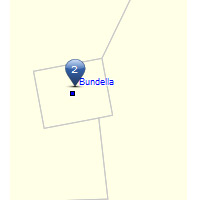
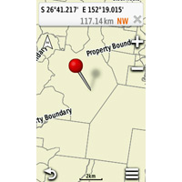 | Contains Searchable Pastoral Station Names & Property Boundaries for QLDIncluding DCDB, stock routes, airfields, homestead locations, and rabbit & dog fences.Queensland Pastoral Stations & Property Boundaries v2 is a mapping product designed for use with Garmin GPS units.It contains serachable pastoral station names, or lot plan number where the station name is not available. Also included are property boundaries, DCDB, stock routes, airfields, homestead locations, and rabbit and dog fences. |
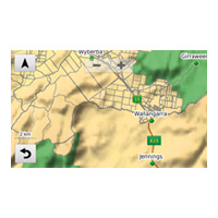 | Mapping Can Be Displayed as an Overlay with other Garmin Mapping ProductsCan be shown over the top of Garmin street mapping.This mapping can be displayed simultaneously and overlayed with other Garmin mapping products (if they have been preloaded on your unit's internal memory).If auto-routing street mapping (such as City Navigator or Garmin Topo) is also loaded to your GPS, then auto-routing instructions will be provided to the nearest listed road on supported units. |
 | Compatible with Most Garmin Map-Capable GPSPlug & play.The mapping is preloaded onto a MicroSD card (With SD adapter) and will work in any compatible Garmin GPS.Simply plug the SD or microSD into your GPS, and the mapping is displayed. |
Package Includes:
- QLD Pastoral Stations V2 on MicroSD
- SD Adapter
Loading compatible items...