
GPSMAP® 86i
Marine handheld GPS with inReach® satellite communication capabilities
Cast off confidently with the GPSMAP® 86i handheld. Whether you’re out for a day of fishing, sailing or cruising, you’ll gain peace of mind that comes from having a backup navigator with satellite communication and interactive SOS. This premium handheld floats and has a sunlight-readable 3" colour display. Plus, wireless connectivity makes it a virtual extension of your onboard marine system, giving you added awareness and convenience.
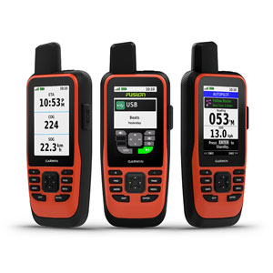
Connect with Your Boat
Sync GPSMAP® 86i with compatible Garmin chartplotters and instruments and you’ll see real-time boat data displayed right on your handheld. Plus, it can serve as a remote control for convenient operation of your Garmin autopilot and select FUSION marine products. When you’re underway, an adjustable GPS filter smooths speed and heading indications over swells for more accurate tracking.
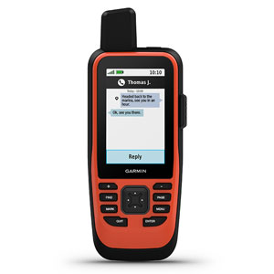
Satellite Communication
With built-in inReach satellite technology and additional service options1, GPSMAP® 86i helps you stay in touch globally. Send and receive two-way text messages, track and share your journey, and, if necessary, trigger an interactive SOS to get emergency help from a 24/7 global monitoring center via the 100% global Iridium satellite network. You can also receive marine weather forecasts directly on your device, so you can make educated decisions based on local conditions or the destination ahead.
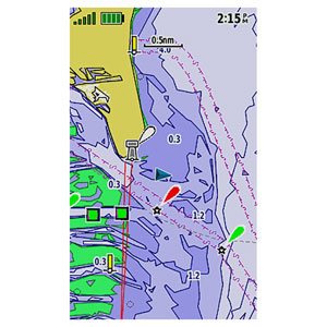
Compatible with BlueChart g2 and g3 Mapping Charts
GPSMAP® 86i comes preloaded with a worldwide basemap. It is also compatible with BlueChart g2 and g3 coastal charts, giving you industry-leading coverage, clarity and detail with integrated Garmin and Navionics® data. Detailed contours allow you to see 30 cm (1 ft) contours that provide a more accurate depiction of bottom structure for improved fishing charts and enhanced detail in swamps, canals and port plans.
Stay In Touch
Get smart notifications right on your GPSMAP® 86i handheld when you pair it with your compatible smartphone. You can also sync GPSMAP® 86i with the Garmin Explore™ portal and app for cloud management of your favourite waypoints, tracks and routes. GPSMAP® 86i offers Wi-Fi® connectivity, ANT+® technology and Bluetooth® wireless technology for easy wireless updates and connections. For long voyages, its internal, rechargeable lithium battery provides up to 35 hours of battery life in 10-minute tracking mode2.
inReach Subscription Cost
To access the Iridium network and communicate with your 86i device, an active satellite subscription is required. There are multiple plans and tiers available depending on your level of usage.
PERSONAL PLANS
For outdoor enthusiasts, adventure seekers, explorers, travelers and anyone who needs a global communications solution, an inReach device and satellite subscription can mean added preparedness and peace of mind when you need to stay connected. Choose our monthly Freedom plan or an annual plan to meet your airtime service needs.
- Monthly Freedom plans are ideal for your next adventure or seasonal use, requiring only a 30-day commitment with the ability to suspend service when you don’t need it.
- Annual plans are great for year-round use, with lower monthly cost and peace of mind that your inReach device is always ready to use.
PROFESSIONAL PLANS
Garmin offers an array of flexible inReach professional solutions that helps keep everyone on your team connected, safe, oriented and informed. Our Professional Flexsubscription plans offer three levels that meet the operational needs of your teams or organization, including the following:
- All Flex plans are month to month and only require a 30-day commitment.
- You can suspend service in the offseason or when staff is not deployed in the field.
- You can move up or down a plan for free when your tracking or communication needs change.
- Enhanced administration tools are available to manage devices, tracking and communications.
- Advanced API provides access to messaging and tracking data.
All prices are subject to change. Prices are correct as of 30/04/2021 (inReach devices require satellite subscription activation to access the Iridium® satellite network for live tracking and messaging functions, including SOS.
All plans are billed monthly. Subscription plans listed above are for individual consumers only. Plans include applicable VAT. Additional charges apply to text messages, tracking points, and location pings exceeding selected plan limits. For Service Plans that include unlimited texting or tracking, message transmission speeds may be reduced following a period of heavy use. SOS message transmission speed will not be impacted. All annual plans are subject to $49 AUD activation fee. No charge applies to changing an annual plan.
Enrolment in Freedom plans is subject to a $54 AUD annual fee. Freedom plans’ minimum term is 30 days. New 30-day minimum applies to changed Freedom plans. No charge applies to changing a Freedom plan. Service can be suspended a month at a time at no charge. User retains access to inReach data stored on Garmin Explore™ portal while account is suspended. Selected plan auto-renews monthly unless user changes account selections in Garmin Explore™ portal.
| PERSONAL PLANS | |||
|---|---|---|---|
| SAFETY | RECREATION | EXPEDITION | |
| SOS | Unlimited | Unlimited | Unlimited |
| Text Messages | 10 | 40 | Unlimited |
| Preset Messages | Unlimited | Unlimited | Unlimited |
| Tracking Intervals | 10+ Minutes | 10+ Minutes | 2+ Minutes |
| Send/Track Points | $0.15 AUD each | Unlimited | Unlimited |
| Location Requests | $0.15 AUD each | Unlimited | Unlimited |
| Basic Weather | 1 text message each | 1 text message each | Unlimited |
| Premium Weather | $1.50 AUD each | $1.50 AUD each | $1.50 AUD each |
| MONTHLY CHARGES | |||
| Annual Plans | $20.00 AUD/month | $40.00 AUD/month | $75.00 AUD/month |
| Freedom Plan | $25.00 AUD/month | $55.00 AUD/month | $99.00 AUD/month |
| OVERAGE CHARGES | |||
| Messages (each) | $0.75 AUD | $0.75 AUD | N/A |
| PROFESSIONAL PLANS | |||
|---|---|---|---|
| BASIC | ADVANCED | UNLIMITED | |
| SOS | Unlimited | Unlimited | Unlimited |
| Text Messages | 20 | 40 | Unlimited |
| Preset Messages | Unlimited | Unlimited | Unlimited |
| Tracking Intervals | 10+ Minutes | 10+ Minutes | 2+ Minutes |
| Send/Track Points | $0.15 AUD each | Unlimited | Unlimited |
| Location Requests | $0.15 AUD each | Unlimited | Unlimited |
| Basic Weather | 1 text message each | 1 text message each | Unlimited |
| Premium Weather | $1.50 AUD each | $1.50 AUD each | $1.50 AUD each |
| MONTHLY CHARGES | |||
| Monthly Flex Fee | $30.00 AUD/month | $55.00 AUD/month | $99.00 AUD/month |
| OVERAGE CHARGES | |||
| Messages (each) | $0.75 AUD | $0.75 AUD | N/A |
| Suspend Fee | $8.00 AUD/month | $8.00 AUD/month | $8.00 AUD/month |
Activate your inReach device at https://inreach.garmin.com
Notes:
- 1 Satellite subscription required
- 2 Battery life may vary depending on usage; battery is user-replaceable
General
| Physical Dimensions | WxHxD: 7 x 17.8 x 4.4 cm |
| Display size | 3.8 x 6.3 cm; 3" diag (7.6 cm) |
| Display resolution | 240 x 400 pixels |
| Display type | Transflective, 65K colour TFT |
| Weight | 272 g |
| Battery | Rechargeable internal lithium ion |
| Battery life | Up to 35 hours in 10-minute tracking mode; up to 200 hours (expedition mode) |
| Water Rating | IPX7 |
| Memory/history | 16 GB |
| High-sensitivity receiver | |
| Interface | High-speed USB and NMEA 0183 compatible |
Maps & Memory
| Ability to add maps | |
| Basemap | |
| Storage and power capacity | microSD card (not included) |
| Waypoints/favourites/locations | 10,000 |
| Routes | 250 |
| Track Log |
|
Sensors
| Barometric altimeter | |
| Compass | Yes (tilt-compensated 3-axis) |
Outdoor recreation features
| Area calculation | |
| Automatic routing (turn by turn routing on roads) | Yes (with optional mapping for detailed roads) |
| Geocaching-friendly | Yes (paperless) |
| Custom maps compatible | |
| Hunt/fish calendar | |
| Sun and moon information | |
| Picture viewer |
Garmin Connect™
| Garmin Connect™ compatible (online community where you analyse, categorise and share data) |
In The Box:
- GPSMAP® 86i handheld with worldwide basemap
- Powered mount
- Lanyard
- USB to Micro USB cable
- USB to 2 pin cable
- Mounting hardware
- Documentation