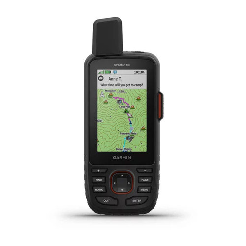


Garmin GPSMAP® 66i
Flagship Handheld GPS and Satellite Communicator with Topo Mapping
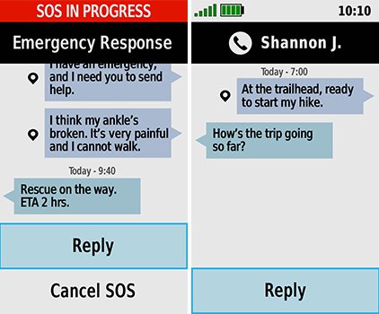
Ever since Garmin purchased DeLorme in 2016, their ultimate goal has been to combine the inReach satellite communication technology, with their flagship handheld GPS for outdoor enthusiasts. This product realises this dream, by combining the world's most capable handheld GPS, with the best satellite communication technology available. Once subscribed to a competitively priced plan, the GPSMAP 66i turns into a powerful communication device that can work off the grid, anywhere in the world. Because it communicates in 2 directions, it can send AND receive messages to any email address, or standard mobile phone number. If the worst comes to worst, you can trigger an SOS alert and communicate with GEOS search and rescue monitoring centre.
Powerful Outdoor Navigation
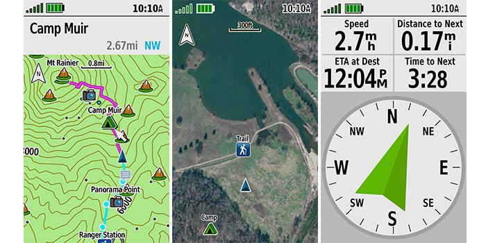
The GPSMAP 66i is fitted with the most powerful navigation toolset Garmin has ever delivered. In addition to multi-GNSS support, the GPSMAP 66i series provides ABC (altimeter, barometer and compass) sensor capabilities to track your journey. The built-in altimeter provides elevation data to accurately monitor ascent and descent, while the barometer can be used to predict weather changes by showing short-term trends in air pressure. The three-axis electronic compass keeps your bearing whether you’re moving or not. The preloaded Topo Active mapping provides detailed views of terrain, contours, elevations, points of interest, tracks, water bodies, coastlines, and other geographic points. Support for BirdsEye satellite imagery provides high-res photo-realistic views without an annual subscription.
inReach Subscription Cost
To access the Iridium network and communicate with your inReach SE, Explorer+ or GPSMAP 66i device, an active satellite subscription is required. There are multiple plans and tiers available depending on your level of usage.
PERSONAL PLANS
For outdoor enthusiasts, adventure seekers, explorers, travelers and anyone who needs a global communications solution, an inReach device and satellite subscription can mean added preparedness and peace of mind when you need to stay connected. Choose our monthly Freedom plan or an annual plan to meet your airtime service needs.
- Monthly Freedom plans are ideal for your next adventure or seasonal use, requiring only a 30-day commitment with the ability to suspend service when you don’t need it.
- Annual plans are great for year-round use, with lower monthly cost and peace of mind that your inReach device is always ready to use.
PROFESSIONAL PLANS
Garmin offers an array of flexible inReach professional solutions that helps keep everyone on your team connected, safe, oriented and informed. Our Professional Flexsubscription plans offer three levels that meet the operational needs of your teams or organization, including the following:
- All Flex plans are month to month and only require a 30-day commitment.
- You can suspend service in the offseason or when staff is not deployed in the field.
- You can move up or down a plan for free when your tracking or communication needs change.
- Enhanced administration tools are available to manage devices, tracking and communications.
- Advanced API provides access to messaging and tracking data.
All prices are subject to change. Prices are correct as of 30/04/2021 (inReach devices require satellite subscription activation to access the Iridium® satellite network for live tracking and messaging functions, including SOS.
All plans are billed monthly. Subscription plans listed above are for individual consumers only. Plans include applicable VAT. Additional charges apply to text messages, tracking points, and location pings exceeding selected plan limits. For Service Plans that include unlimited texting or tracking, message transmission speeds may be reduced following a period of heavy use. SOS message transmission speed will not be impacted. All annual plans are subject to $49 AUD activation fee. No charge applies to changing an annual plan.
Enrolment in Freedom plans is subject to a $54 AUD annual fee. Freedom plans’ minimum term is 30 days. New 30-day minimum applies to changed Freedom plans. No charge applies to changing a Freedom plan. Service can be suspended a month at a time at no charge. User retains access to inReach data stored on Garmin Explore™ portal while account is suspended. Selected plan auto-renews monthly unless user changes account selections in Garmin Explore™ portal.
| PERSONAL PLANS | |||
|---|---|---|---|
| SAFETY | RECREATION | EXPEDITION | |
| SOS | Unlimited | Unlimited | Unlimited |
| Text Messages | 10 | 40 | Unlimited |
| Preset Messages | Unlimited | Unlimited | Unlimited |
| Tracking Intervals | 10+ Minutes | 10+ Minutes | 2+ Minutes |
| Send/Track Points | $0.15 AUD each | Unlimited | Unlimited |
| Location Requests | $0.15 AUD each | Unlimited | Unlimited |
| Basic Weather | 1 text message each | 1 text message each | Unlimited |
| Premium Weather | $1.50 AUD each | $1.50 AUD each | $1.50 AUD each |
| MONTHLY CHARGES | |||
| Annual Plans | $20.00 AUD/month | $40.00 AUD/month | $75.00 AUD/month |
| Freedom Plan | $25.00 AUD/month | $55.00 AUD/month | $99.00 AUD/month |
| OVERAGE CHARGES | |||
| Messages (each) | $0.75 AUD | $0.75 AUD | N/A |
| PROFESSIONAL PLANS | |||
|---|---|---|---|
| BASIC | ADVANCED | UNLIMITED | |
| SOS | Unlimited | Unlimited | Unlimited |
| Text Messages | 20 | 40 | Unlimited |
| Preset Messages | Unlimited | Unlimited | Unlimited |
| Tracking Intervals | 10+ Minutes | 10+ Minutes | 2+ Minutes |
| Send/Track Points | $0.15 AUD each | Unlimited | Unlimited |
| Location Requests | $0.15 AUD each | Unlimited | Unlimited |
| Basic Weather | 1 text message each | 1 text message each | Unlimited |
| Premium Weather | $1.50 AUD each | $1.50 AUD each | $1.50 AUD each |
| MONTHLY CHARGES | |||
| Monthly Flex Fee | $30.00 AUD/month | $55.00 AUD/month | $99.00 AUD/month |
| OVERAGE CHARGES | |||
| Messages (each) | $0.75 AUD | $0.75 AUD | N/A |
| Suspend Fee | $8.00 AUD/month | $8.00 AUD/month | $8.00 AUD/month |
Activate your inReach device at https://inreach.garmin.com
General
| Physical dimensions | 2.6" x 6.4" x 1.4" (6.6 x 16.3 x 3.5 cm) |
| Weight | 8.5 oz (241 g) with internal battery |
| Water rating | IPX7 |
| Battery | Rechargeable internal lithium-ion |
| Battery Life |
|
| Display type | transflective color TFT |
| Display size | 1.5"W x 2.5"H (3.8 x 6.3 cm); 3" diag (7.6 cm) |
| Display resolution | 240 x 400 |
| Memory/History | 16 GB |
| High Sensitivity Receiver | |
| Interface | high-speed USB and NMEA 0183 compatible |
Maps & Memory
| Ability to add maps | |
| Basemap | |
| Storage and Power Capacity | microSD™ card (not included) |
| Waypoints/favorites/locations | 10000 |
| Routes | 250 |
| Track log | 20000 points, 250 saved gps tracks, 300 saved fit activities |
| Preloaded maps | yes (topo active) |
| GDA2020 Support |
Sensors
| Barometric Altimeter | |
| Compass | Yes (tilt-compensated 3-axis) |
Outdoor Recreation Features
| Area calculation | |
| Automatic routing (turn by turn routing on roads) | Yes (with topo active) Please note: Turn by turn routing does not show street numbers. Address selection is unavailable on this device. |
| Geocaching-friendly | Yes (Paperless) |
| Custom maps compatible | |
| Hunt/fish calendar | |
| Sun and moon information | |
| Picture viewer |
Garmin Connect™
| Garmin Connect™ compatible (online community where you analyze, categorize and share data) |
Additional
| Additional |
|
In The Box:
- GPSMAP 66i
- Access to BirdsEye Satellite Imagery
- USB cable
- Carabiner clip
- Documentation