
Rugged, portable navigator with 3D vision and wireless capabilities

Advanced features in a light, compact package
The lightweight, compact aera 660 fits in any flight bag and comes packed with features using the latest in Garmin technology. As a dedicated navigator, it quickly and reliably acquires GPS and GLONASS satellite consellations and combines advanced navigation tools with rich, interactive, dynamically drawn aviation maps all displayed on a 5 inch, bright and sunlight-readable diagonal capacitive touchscreen display. For those who are familiar with the Garmin GTN™ touchscreen GPS/NAV/COMM, G5000® integrated flight deck of even the Garmin Pilot™ app you will have no trouble using the intuitive interface to quickly pan across the map screen, pinch to zoom and more. A quick settings menu is available through the use of the power button on the top which allows you to change from portrait to landscape orientation, volume and brightness and more and the aera 660 comes with a snap-in style powered mount for easy transportation between your aircraft and home.
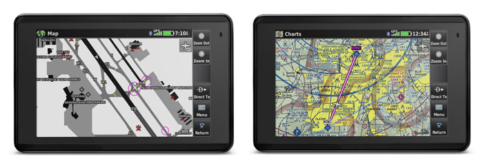
Complete Flight Mapping
The aera 660 aviation portable comes preloaded with detailed flight mapping (including Australia Pacific Jeppesen database), terrain and obstacles alerting. View overheard and vertical profiles of the topography beneath you with the graphical Terrain page. With IFR map mode, you can display and navigate on high or low enroute airways and the touchscreen map cursor can reference METAs (Minimum Enroute Altitudes) and distances between intersections. The aera 660 can even provide vertical navigation (VNAV) guidance to simplify en-route transitions.
Compatible with numerous Garmin avionic devices
With an optional power/data cable (sold seperately) you are able to connect with your Garmin avionics. Accept flight plans from your GN 750/650 and GNS 530W/430W navigators and upload frequencies to the standby position of your GTR 200 Comm radio, GTR 225 Comm radio or GNC 255 NAV/COMM radio. You can also provide your Garmin NAV/COMM radios with the GPS position source required to look up nearest frequencies.
Bluetooth® technology for an improved flying experience
The aera 660 can easily interface with compatible devices using Bluetooth® connectivity via Garmin Connext. Control your Garmin VIRB® action cameras wirelessly with this device so you can start and stop recording and capture photos.
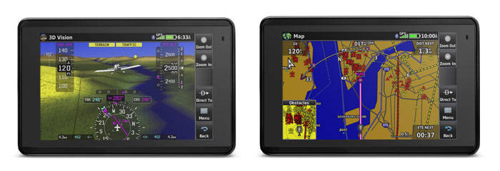
3D Vision technology
aera 660 comes with the revolutionary 3D Vision technology giving you with a virtual 3-D behind-the-aircraft perspective view of surrounding terrain derived from GPS/GLONASS and the onboard terrain database. Slide your finger across the touchscreen to rotate the view and show land and water features, obstacles, runways and airport signposts in relative proximity to the aircraft. Connect to an attitude source (such as a Flight Stream 210, GDL 39 series portable ADS-B data link or a GTX 345 ADS-B transponder) and Garmin SVX synthetic vision and attitude command bars will automatically appear on your display. Additionally, the aera 660 comes with forward-looking terrain avoidance capabilities which allows the device to predict in advance where towers or ostables may exist and then shades the landscape with amber or red overlays to indicate those areas.
Physical and Performance
| Physical Dimensions (W x H x D): | 14.1 x 8.7 x 2.1 cm (5.5" x 3.4" x 0.8") |
| Display size (W x H): | 11.1 x 6.6 cm (4.35" x 2.61"), 5.08" diag (12.9cm) |
| Display resolution: | 480 x 800; portrait and landscape orientation |
| Display type: | touchscreen WVGA color TFT with backlight |
| Weight: | 245 g with battery, 205 g without battery |
| Battery: | removeable, rechargeable lithium-ion |
| Battery life: | Up to 4 hours during most daytime conditions, (80% backlight) and wireless connectivity in the cockpit, e.g. GTX 345; up to 6 hours during typical nighttime conditions, (5% backlight) and without wireless connectivity |
| SBAS/WAAS/GLONASS receiver: | high-sensitivity with WAAS position accuracy |
| Voltage range: | 10 - 35 |
| IFR or VFR: | VFR |
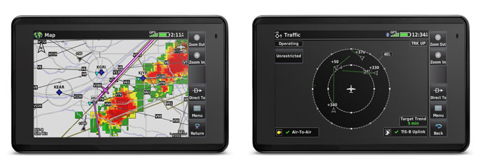
| Traffic Information Services (TIS) alerts compatible: | Yes |
| Accepts data cards: yes (microSD™ cards): | Yes |
What's included:
- aera 660
- Yoke mount with power cable (010-12373-00).
- Battery
- AC adapter
- USB cable
- Quick start manual and related documentation