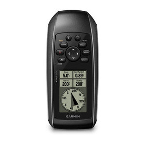


 | High-Sensitivity GPS Marks & Stores 1,000 Waypoints & 100 TracksMarks your favorite locations to easily navigate back to themThis easy-to-use handheld is the perfect navigational solution for boats, sailboats or small watercraft that do not have a chartplotter.It’s also ideal as an important emergency navigation backup for all vessels. Its high-sensitivity GPS marks and stores waypoints and tracks so you can navigate right back to them. Whether it’s a hot fishing spot or a lobster pot, you can mark and store 1,000 waypoints and 100 tracks to navigate to and from time and time again. Use on land or water — it even floats! |
 | Garmin SailAssistIncludes virtual starting line, heading line, countdown timers and tack assistSailAssist helps you sail more effectively with heading line and tack assist. Tack assist lets you know when to tack based on whether your boat is getting headed or lifted compared to the boat's optimal tacking angle. For those who like to race, there’s virtual starting line and countdown timer to make sure you cross the starting line at the right time.GPS 73 is NMEA 0183 compatible. To transfer data to your device, it easily connects to your computer via USB. If you're into boating, hunting or fishing, you can use the built-in celestial data, which includes sunrise/sunset times and a hunting and fishing calendar, estimated time of arrival, other calculations and marine data. GPS 73 has an intuitive user interface with dedicated back-lit buttons for quick and easy operation. Its high-contrast display makes it easy to read in all lighting conditions. |
Physical and Technical
Maps and Memory
Features
Specifications are provided as a guide only, and are subject to change without notice.
| Dimensions (W x H x D): | 6.6 x 152.2 x 3.0 cm (2.6" x 6.0" x 1.2") |
| Display Size (W x H): | 3.6 x 5.4 cm (1.4" x 2.1"); 2.6" diag (6.6 cm) |
| Display Resolution (W x H): | 120 x 160 pixels |
| Display Type: | 4 level grey LCD |
| Weight: | 203.1 g with batteries |
| Battery: | 2 AA batteries (not included) |
| Battery Life: | 18 hours |
| Waterproof: | Yes (IPX7) |
| Floats: | Yes |
| High-sensitivity Receiver: | Yes |
| Interface: | serial and USB |
Maps and Memory
| Basemap: | No |
| Preloaded Street Maps: | No |
| Ability to Add Maps: | No |
| Built-in Memory: | No |
| Accepts Data Cards: | No |
| Waypoints: | 1000 |
| Routes: | 50 |
| Track Log: | 10,000 points, 100 tracks |
Features
| Automatic Routing (turn by turn routing on roads): | No |
| Electronic Compass: | No |
| Touchscreen: | No |
| Barometric Altimeter: | No |
| Camera: | No |
| Geocaching-friendly: | No |
| Outdoor GPS Games: | No |
| Hunt/fish Calendar: | Yes |
| Sun & Moon Information: | Yes |
| Tide Tables: | No |
| Area Calculation: | Yes |
| Custom POIs (ability to add additional points of interest): | No |
| Unit-to-unit Transfer (shares data wirelessly with similar units): | No |
| Picture Viewer: | No |
Specifications are provided as a guide only, and are subject to change without notice.
Package Includes:
- GPS 73
- Lanyard
- Quick start manual
Loading compatible items...