
Garmin GPSMAP 1022xsv
Chartplotter/Sonar Combo
Overview:
Experience an advanced all-in-1 solution with our 10-inch GPSMAP 1022xsv keyed combo. comes with or without a transducer for Garmin CHIRP sonar, CHIRP ClearVü and CHIRP SideVü. It also has built-in support for Panoptix all-seeing sonar and premium Garmin sonar modules (transducers sold separately). Features a large, bright screen coupled with a quick and easy-to-use keypad interface with user-programmable keys and a multifunction control knob.
Complete Network Sharing
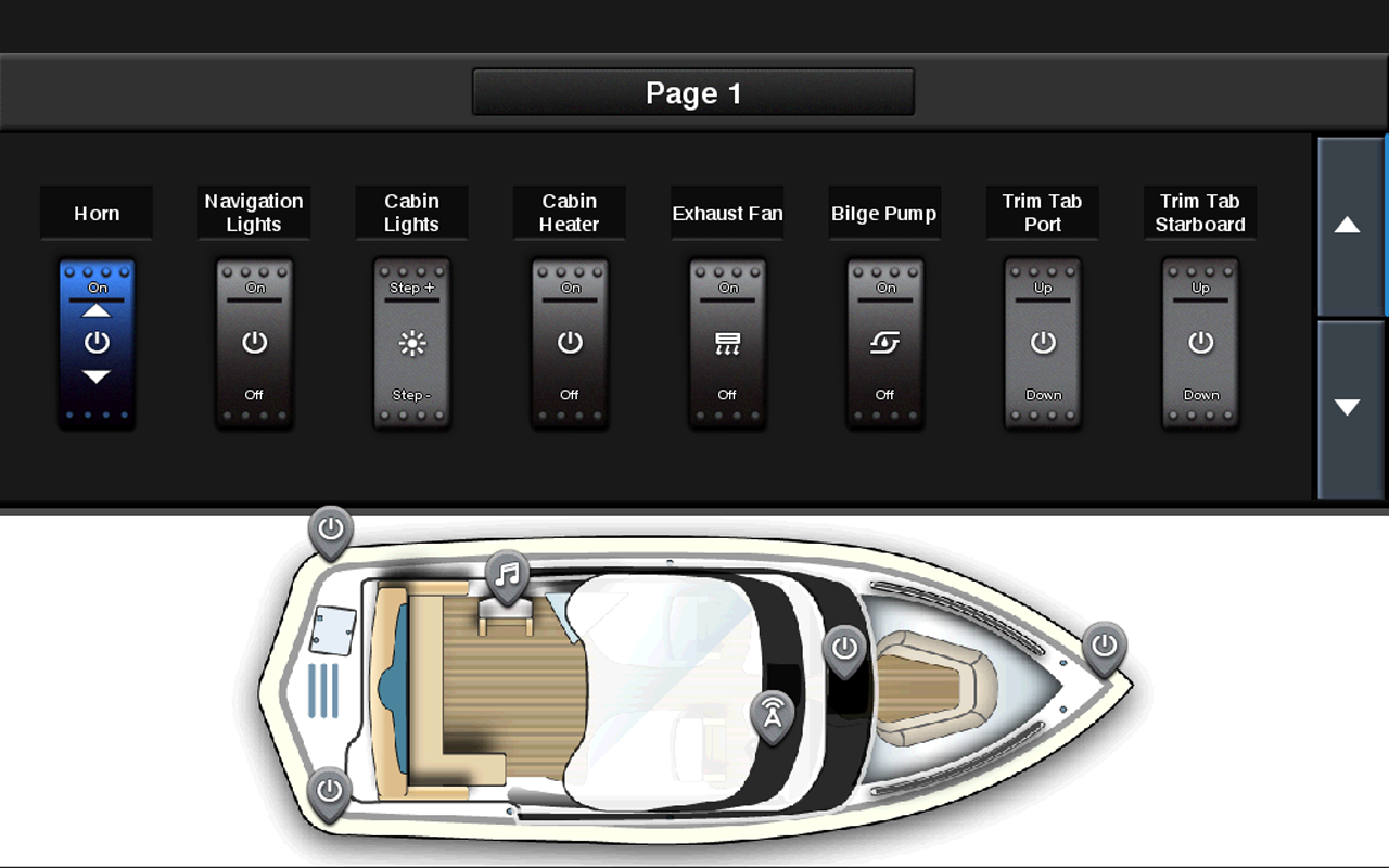
Garmin Marine Network support allows sharing of sonar, maps, user data, dome or open-array radar, IP cameras and Panoptix™ sonar among multiple units. Includes NMEA 2000 network connectivity and NMEA 0183 support for autopilots, digital switching, weather, FUSION-Link, VHF, AIS and other sensors.
Built-in Wi-Fi® Connectivity
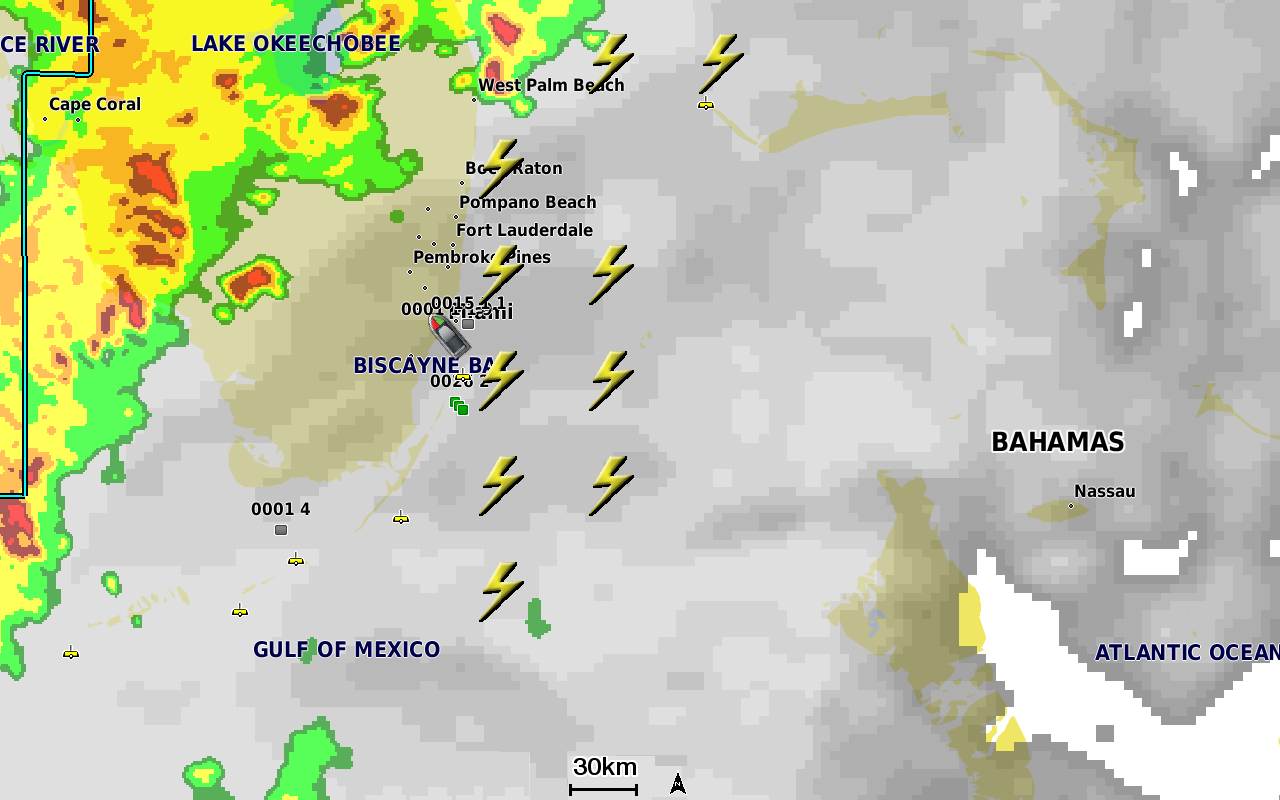
Enjoy built-in Wi-Fi connectivity for BlueChart Mobile 2.0 and Garmin Helm apps. Garmin Helm allows you to view and control your compatible chartplotter from a compatible smartphone or tablet while providing enhanced situational awareness for the mariner. With BlueChart Mobile, a free app downloaded from the App Store™, you can get reliable weather information while you plan marine routes on your iPad® or iPhone® then wirelessly transfer them to your boat’s compatible networked Garmin chartplotter. You can even stream and control a VIRB action camera from the chartplotter.
Built-in ANT® Connectivity
Enjoy built-in ANT wireless connectivity directly to quatix® marine watch, Garmin Nautix™ in-view display, gWind™ Wireless 2 transducer, GNX™ Wind marine instrument and wireless remote controls.
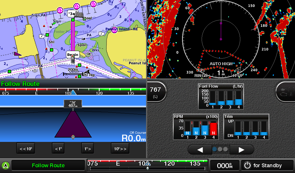
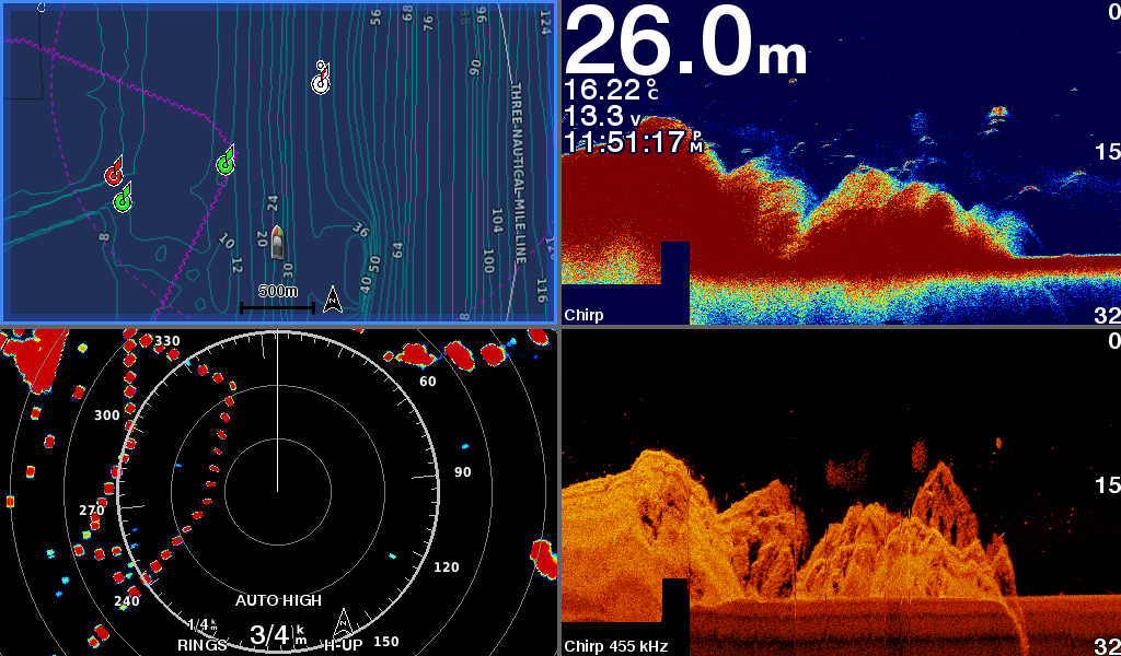
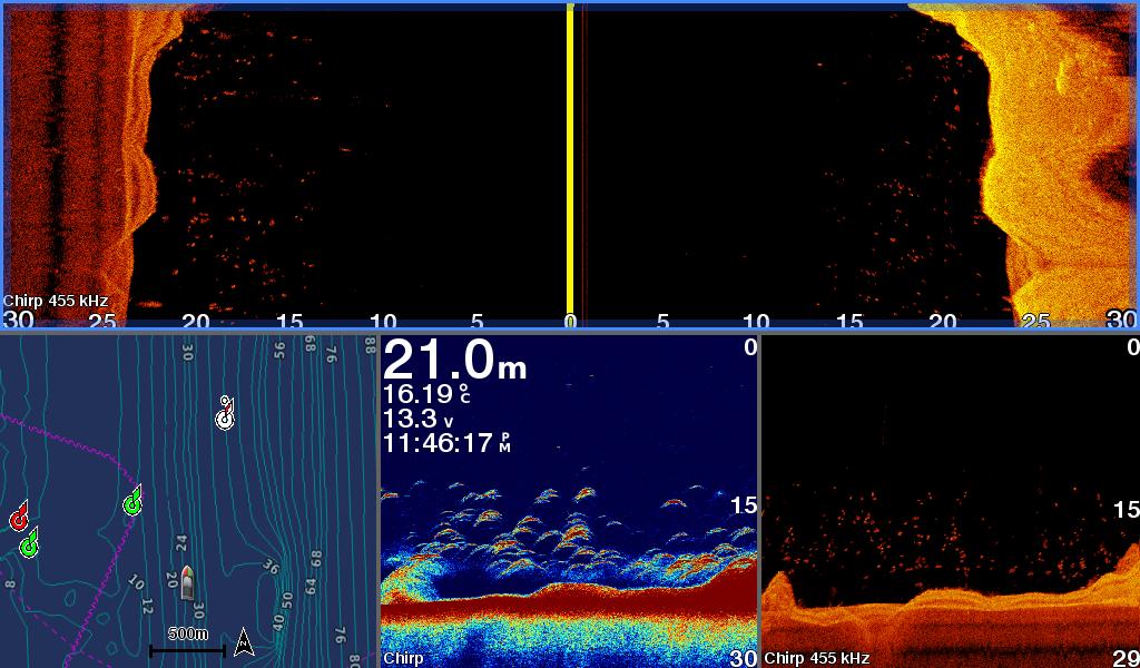
Built-in Sonar Capabilities
Right out of the box, you have access to some amazing sonar capabilities; all you have to add are transducers. Comes with built-in Garmin 1 kW CHIRP sonar, CHIRP ClearVü and CHIRP SideVü scanning sonar. It even supports Panoptix all-seeing sonar, premium Garmin sonar modules and a wide range of transducers (sold separately).
Networked combos can share their internal sonar with any other device on the network. You can also choose what information is overlaid on the sonar screen; for example, radar, time of day or GPS speed.
Heading, Position Refreshed 10 Times per Second
Fast, responsive built-in 10 Hz GPS and GLONASS receiver refreshes your position and heading 10 times each second to make your movement on the screen more fluid. It makes dropping up to 5,000 accurate waypoints — and finding your way back to them — quick and easy.
Upgrade to Our Best Maps on the Water
Two SD™ card slots provide expandable memory for accessory map purchases, such as BlueChart® g2 HD or BlueChart® g2 Vision® HD, which adds Garmin patented Auto Guidance¹ and other great features.
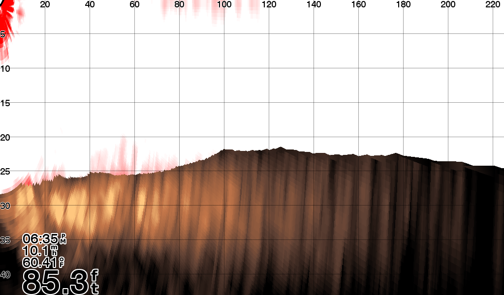
Quickdraw Contours to Create Your Own HD Maps
Instantly create personalised HD fishing maps on screen with 1-foot contours. Tailor them to fit your needs. These are your maps — you own them. Keep the data to yourself, or share it with the Quickdraw Community on Garmin Connect™.

Built-in SailAssist Features
To help you gain a wind-maximizing competitive edge, your chartplotter features a pre-race guidance page that shows your virtual starting line along with data fields showing laylines, time to burn before the start and a race timer that can be synchronized across all your networked Garmin GPS products. In addition, other supported sailing features include an enhanced wind rose, heading and course-over-ground lines, set and drift, true and apparent wind data and more.
GPX Waypoints Transfer
If you have waypoints, tracks or frequently used routes stored on another manufacturer’s GPS product — or on a Garmin handheld device — it’s easy to transfer those items to your new Garmin chartplotter via industry-standard GPX software formatting.
General Specifications
| Physical dimensions | 12.5" x 7.3" x 2.7" (318 x 185 x 69 cm) |
| Display size, WxH | 8.8" x 4.9" (224 x 125 cm) |
| Display resolution, WxH | 1024 x 600 pixels |
| Display type | WSVGA display |
| Weight | 1.85 kgs |
| Antenna | Internal or external over NMEA 2000 |
| NMEA 2000® compatible | |
| NMEA 0183 compatible | |
| SiriusXM™ Weather & Radio compatible | |
| Power consumption |
|
| Mounting options | Bail or Flush |
| Garmin Marine Network™ ports | 2 |
Maps & Memory
| Preloaded Maps | None |
| Accepts data cards | 2 SD™ cards |
| Waypoints | 5,000 |
| Routes | 100 |
| Track log | 50,000 points; 50 saved tracks |
Chartplotter Features
| Garmin Radar compatible | |
| Garmin Sonar compatible | Yes (built-in) |
| Garmin SmartMode compatible (customizable monitor presets) | |
| Supports AIS (tracks target ships position) | |
| Supports DSC (displays position data from DSC-capable VHF radio) | |
| Tide tables | |
| Garmin Meteor™ Audio System compatible | |
| Supports FUSION-Link™ compatible radios | |
| GSD™ Black Box sonar support | |
| GCV™ Black Box sonar support | |
| BlueChart® Mobile (planning) compatible | |
| Garmin Helm™ compatible | |
| GRID™ (Garmin Remote Input Device) compatibl | |
| Wireless remote compatible |
Sonar Features & Specification
| Dual-frequency (50/200 kHz) sonar capable | |
| Dual-beam (77/200 kHz) sonar capable | |
| Frequencies supported |
|
| Transmit power | 1 kW traditional; 1 kW CHIRP |
| CHIRP sonar technology | Yes (Built-in) |
| ClearVü | Yes with CHIRP (built-in) |
| SideVü | Yes with CHIRP (built-in) |
| Maximum depth | 5,000 ft at 1kW (depth capacity is dependent on water bottom type and other water conditions) |
| Bottom lock (shows return from the bottom up) | |
| Water temperature log and graph | |
| Sonar recording | |
| Sonar history rewind |
Connections
| Transducer Pin numbers | 12 |
| NMEA 0183 input ports | 1 |
| NMEA 0183 output ports | 1 |
| Video input ports | 1 BNC |
| Video output ports | None |
| Wireless connectivity |
In the box:
- GPSMAP 1022xsv chartplotter
- Power/data cable
- NMEA 2000 T-Connector
- NMEA 2000 drop cable (2m)
- 8-pin transducer to 12-pin sounder adapter cable
- Bail mount kit with knobs
- Flush mount kit with gasket
- Protective cover
- Trim piece snap covers
- Documentation