


Montana 750i
Rugged GPS Touchscreen Navigator with inReach® Technology and 8 Megapixel CameraSEE THE WORLD. STAY IN TOUCH. BE THE PICTURE OF ADVENTURE.
The rugged Montana 750i handheld combines the flexibility of on- or off-road navigation with global messaging and interactive SOS via inReach satellite technology1 — plus a built-in 8-megapixel camera..

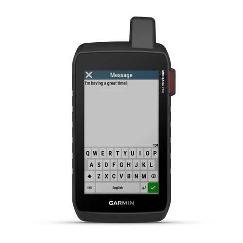
Big news. A full QWERTY keyboard lets you easily type messages.

Wander wider and still stay in touch — with inReach for messaging and 24/7 SOS.

Nav, meet cam. Put your trip pics on the map with geotags.

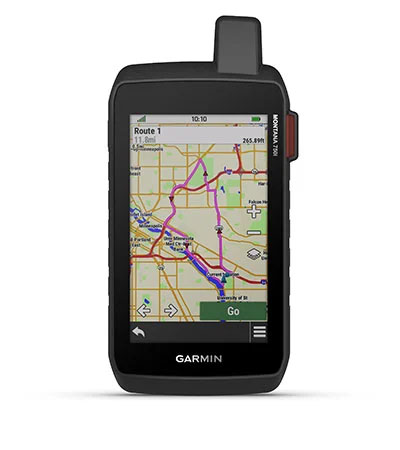
Routable topographic maps? Check. Now you’re free to take it off-road or on.

Built like a tank. Meets MIL-STD 810 for thermal, shock, water and vibration.

Power your adventures with 18+ hours of lithium-ion battery life in GPS mode.
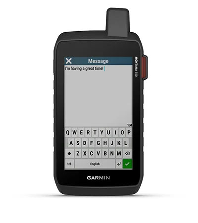
TWO-WAY MESSAGING
Exchange text messages with loved ones, post to social media, or communicate via inReach device to inReach device in the field (active satellite subscription required, details below).
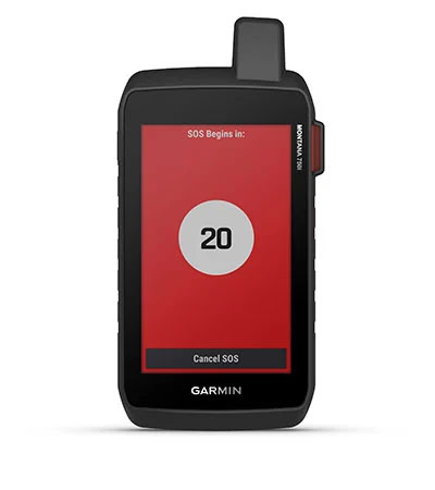
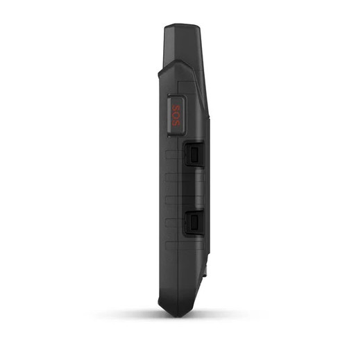
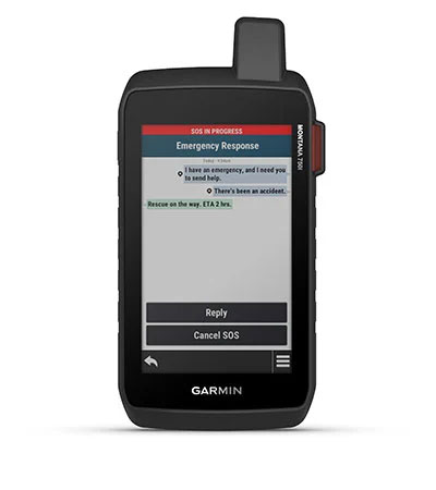
INTERACTIVE SOS
In case of emergency, trigger an interactive SOS message to GEOS, a professional 24/7 global monitoring and response center (active satellite subscription required, details below).
GLOBAL CONNECTIVITY
Instead of relying on cellphone coverage, now your messages, SOS and tracking are transferred via the 100% global Iridium® satellite network (active satellite subscription required, details below).
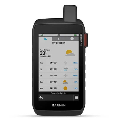
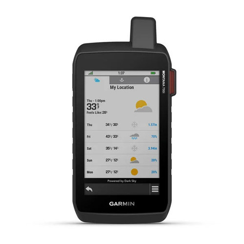
ACTIVE WEATHER
Available inReach weather forecast service provides detailed updates directly to your Montana handheld or paired devices, so you’ll know what to expect en route.
Born to explore.
Built to endure.
RUGGED BY DESIGN
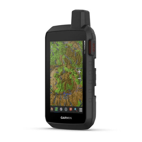
This durable, water-resistant handheld is tested to U.S. military standards and features a glove-friendly 5" touchscreen that’s 50% larger than previous Montana models.
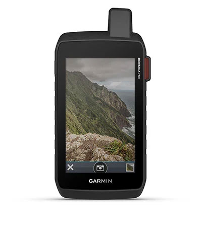
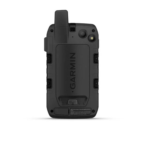
BUILT-IN CAMERA
Capture images of your exploits with Montana’s digital 8-megapixel camera. It geotags photos with coordinates, so you can navigate back to favorite sites in the future.
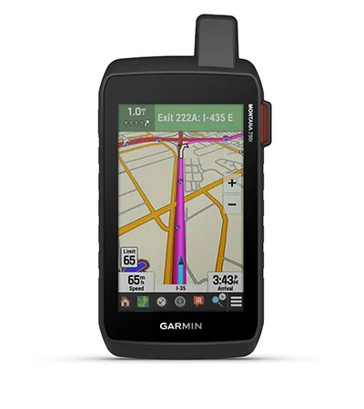
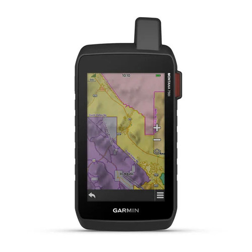
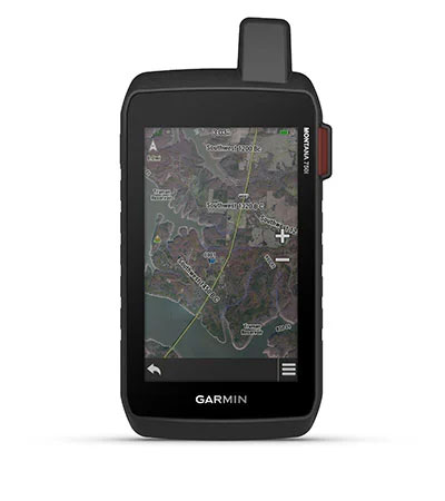
CITY NAVIGATOR MAPS
Seamlessly transition from trails to road navigation with preloaded City Navigator street mapping, which guides your drive with easy-to-follow turn-by-turn directions.
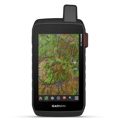
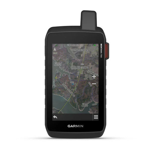
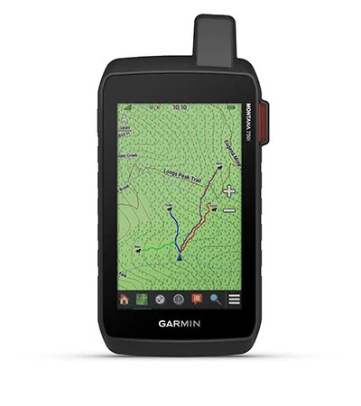
FULL TOPOGRAPHIC MAPPING
To navigate your adventures, use preloaded full topographical maps for Australia & New Zealand. View terrain contours, elevations, coastlines, rivers, landmarks and more.
SATELLITE VIEWS
Use direct-to-device downloads of BirdsEye Satellite Imagery (no annual subscription required) to see photo-realistic views and create waypoints based on landmarks.
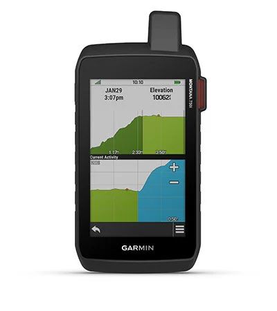
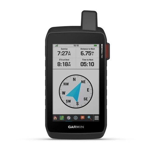
ABC SENSORS
Navigate your next trail with ABC sensors, including an altimeter for elevation data, barometer to monitor weather and 3-axis electronic compass.
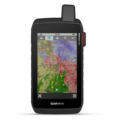
ACTIVE WEATHER
Use cellular connectivity2 to access up-to-date Active Weather forecasts through the Garmin Connect™ app.
DOG TRACKING
For hunters and trainers, this Montana syncs with compatible Astro® or Alpha® series handhelds (sold separately) to help track sporting dogs in the field.
Take off where others leave off.
MULTI-GNSS SUPPORT
Access to both GPS and Galileo satellite networks enables Montana 750i to track in more challenging environments than GPS alone.
TRACKING
Using your web-based MapShare™ trip-sharing page, followers can see your progress, ping your device to see your GPS location and exchange messages during your trip.
EXPEDITION MODE
Trek far and wide off-grid. Use Expedition mode, an ultralow-power GPS reference, to keep Montana tracking for a week or more between recharges.
BATTERY OPTIONS
An internal, rechargeable lithium-ion battery pack provides more than 18 hours of battery life in GPS mode.
VEHICLE MOUNTS
A variety of Montana handheld-compatible mounts (sold separately) lets you adapt your navigator for use on ATVs, boats, cars, motorcycles, RVs or other vehicles.
inReach Subscription Cost
You’ll need an active satellite subscription to access the Iridium satellite network for tracking, messaging and interactive SOS. Check out Garmin's subscription options below:
All prices are subject to change. Prices are correct as of 30/04/2021 (inReach devices require satellite subscription activation to access the Iridium® satellite network for live tracking and messaging functions, including SOS.
FREEDOM PLANS:
- Monthly service; only requires a 30-day commitment
- Suspend service when you don’t need it
- Perfect for single adventures or seasonal use
ANNUAL PLANS:
- Year-round use
- Lower monthly cost
- Always ready for your adventures
| PLANS AVAILABLE | |||
|---|---|---|---|
| SAFETY | RECREATION | EXPEDITION | |
| SOS | Unlimited | Unlimited | Unlimited |
| Text Messages | 10 | 40 | Unlimited |
| Preset Messages | Unlimited | Unlimited | Unlimited |
| Tracking Intervals | 10+ Minutes | 10+ Minutes | 2+ Minutes |
| Send/Track Points | $0.15 AUD each | Unlimited | Unlimited |
| Location Pings | $0.15 AUD each | Unlimited | Unlimited |
| Basic Weather | 1 text message each | 1 text message each | Unlimited |
| Premium Weather | $1.50 AUD each | $1.50 AUD each | $1.50 AUD each |
| Premium Marine Weather | $1.50 AUD each | $1.50 AUD each | $1.50 AUD each |
| MONTHLY CHARGES | |||
| Annual Plans | $20.00 AUD/month | $40.00 AUD/month | $75.00 AUD/month |
| Freedom Plan | $25.00 AUD/month | $55.00 AUD/month | $99.00 AUD/month |
| OVERAGE CHARGES | |||
| Messages (each) | $0.75 AUD | $0.75 AUD | N/A |
All plans are billed monthly. Subscription plans listed above are for individual consumers only. Plans include applicable VAT. Additional charges apply to text messages, tracking points, and location pings exceeding selected plan limits. For Service Plans that include unlimited texting or tracking, message transmission speeds may be reduced following a period of heavy use. SOS message transmission speed will not be impacted. All annual plans are subject to $49 AUD activation fee. No charge applies to changing an annual plan.
Enrolment in Freedom plans is subject to a $54 AUD annual fee. Freedom plans’ minimum term is 30 days. New 30-day minimum applies to changed Freedom plans. No charge applies to changing a Freedom plan. Service can be suspended a month at a time at no charge. User retains access to inReach data stored on Garmin Explore™ portal while account is suspended. Selected plan auto-renews monthly unless user changes account selections in Garmin Explore™ portal.
1 Active satellite subscription required. Some jurisdictions regulate or prohibit the use of satellite communications devices. It is the responsibility of the user to know and follow all applicable laws in the jurisdictions where the device is intended to be used.
2 When paired with a compatible smartphone
General
| Physical Dimensions | 3.6" x 7.2" x 1.3" (9.19 x 18.30 x 3.27 cm) |
| Touchscreen | |
| Display Size | 2.55"W x 4.25"H (6.48 x 10.80 cm); 5" diag (12.70 cm) |
| Display Resolution | 480 x 800 pixels |
| Display Type | WVGA transflective, dual orientation |
| Weight | 410 g (14.5 oz) with included lithium-ion battery pack |
| Battery Type | rechargeable lithium-ion (included) |
| Battery Life |
|
| Water Rating | IPX7 |
| MIL-STD-810 | yes (thermal, shock, water, vibe) |
| High-sensitivity Receiver | |
| Interface | high speed micro USB and NMEA 0183 compatible |
| Memory/History | 16 GB (user space varies based on included mapping) |
Maps & Memory
| Preloaded Maps | Full Topo Australia/New Zealand & City Navigator |
| Ability to Add Maps | |
| Basemap | |
| Automatic routing (turn-by-turn routing on roads) | Yes (with optional mapping for detailed roads) |
| Map Segments | 15000 |
| BirdsEye | yes (direct to device) |
| Includes detailed hydrographic features (coastlines, lake/river shorelines, wetlands and perennial and seasonal streams) | |
| Includes searchable points of interest (parks, campgrounds, scenic lookouts and picnic sites) | |
| Displays national, state and local parks, forests and wilderness areas | |
| External memory storage | yes (32 GB max microSD™ card) |
| Waypoints/favourites/locations | 10000 |
| Tracks | 250 |
| Track log | 20000 points, 250 saved gpx tracks, 300 saved fit activities |
| Routes | 250, 250 points per route; 50 points auto routing |
| RINEX Logging | |
| GDA2020 Support |
Sensors
| GPS | |
| GALILEO | |
| Barometric Altimeter | |
| Compass | Yes (tilt-compensated 3-axis) |
| GPS Compass (while moving) |
Daily Smart Features
| Connect IQ™ (Downloadable watch faces, data fields, widgets and apps) | |
| Weather | |
| VIRB® Remote | |
| Pairs with Garmin Connect™ Mobile | |
| Active Weather | |
| Smart Notifications on Handheld |
Safety and Tracking Features
| LiveTrack |
Outdoor Recreation
| Point-to-Point Navigation | |
| Compatible with BaseCamp™ | |
| Area Calculation | |
| Hunt/Fish Calendar | |
| Sun and Moon Information | |
| XERO™ Locations | |
| Geocaching-friendly | |
| Custom Maps Compatible | |
| Picture Viewer | |
| Camera | yes (8 megapixel with autofocus; automatic geo-tagging) |
| LED Beacon Flashlight |
InReach® Features
| Interactive SOS | |
| Send and Receive Text Messages to SMS and Email | |
| Send and Receive Text Messages to other InReach Device | |
| Exchange Locations with other InReach Device | |
| MapShare Compatible with Tracking | |
| Virtual Keyboard for Custom Messaging | |
| Send Waypoints to MapShare During Trip | |
| Send Route Selection to MapShare During Trip | |
| InReach Remote Compatible |
Two-Way Radio Features
| Contacts |
Outdoor Applications
| Compatible with Garmin Explore™ App | |
| Garmin Explore Website Compatible | |
| Dog Tracking | yes (when paired to compatible dog track system) |
Connections
| Wireless Connectivity | yes (Wi-Fi®, BLUETOOTH®, ANT+®) |
In The Box
- Montana 750i GPS
- Li-ion battery pack
- USB cable
- Documentation